Posted: 29 Jun 2010 11:37 AM PDT
Click for video
Weird news report from 1984 near Grand Coulee Dam in Eastern Washington:
No one can figure out how, but a chunk of earth weighing tons was plucked out of a wheat field, as though someone used "a giant cookie cutter," and put down, right side up, 73 feet away. "All we know for sure is that this puzzle piece of earth is 73 feet away from the hole it came out of," said Greg W. Behrens, a geologist with the Bureau of Reclamation at Grand Coulee Dam.
Scientists now believe that the "Cookie Cutter Phenomenon" is caused by two seismic events intersecting, creating constructive interference, and ejecting out a small chunk of earth.
**********
THE COOKIE-CUTTER PHENOMENON
Two articles on the Washington state 1984 event:
Strange Happening - Scientists are baffled by big 'mystery hole'
No one can figure out how, but a chunk of earth weighing tons was plucked out of a wheat field, as though someone used "a giant cookie cutter," and put down, right side up, 73 feet away. "All we know for sure is that this puzzle piece of earth is 73 feet away from the hole it came out of," said Greg W. Behrens, a geologist with the Bureau of Reclamation at Grand Coulee Dam. The displaced slab, mostly soil held together by roots, is about 10 feet long and 7 feet wide. Its thickness varies from 2 feet at one end to about 18 inches at the other. The shape and thickness of the piece exactly match the hole that was left behind, just like a piece in a jigsaw puzzle, though it was rotated about 20 degrees. There are no marks to indicate machines were used, the Seattle Times reported Friday, and the land is fairly flat. "You'd think that, whatever the cause, the chunk would have traveled in a straight line," said Don Aubertin, director of mining for the Colville Indians, whose reservation is near the site. However, a scientist "found where pieces had dribbled from the chunk as it moved. The dribblings traced an arc from the hole to where the chunk was found." The site is on a farm in north-central Washington operated by Fred Timm and his sons. Two of the sons, Rick and Pete, discovered the displaced earth Oct. 18 while rounding up cattle in an area known as "haystack rocks," where huge boulders were left by a glacier that covered the area thousands of years ago. The Timms believe the chunk was moved sometime after mid-September, when they harvested wheat in that field. There was a small earthquake in the area during that one-month period, at 8:24 p.m. Oct. 9. It measured 3.0 on the Richter scale of ground movement, and its epicenter was about 20 miles southwest of the displaced earth. However, University of Washington scientists ruled out the possibility that the quake somehow could have moved the chunk. The work of a meteorite also has been ruled out. "There was no sign of impact," Aubertin said. "The hole was not a crater. It had vertical walls and a fairly flat bottom. It was almost as if it had been cut out with a giant cookie cutter." But even that couldn't have left such a hole, he added, because roots from plants in the piece that was moved still dangled from the walls of the hole, indicating they were torn apart rather than cut. Behrens wondered if bedrock could have focused the earthquake's seismic waves on the displaced chunk.Focusing can occur, said UW geologist Stephen Malone, but it could not provide enough energy.
Washington State's Mystery Hole
Fred Timm owns a farm on the Colville Indian Reservation in northeastern Washington. Nothing notable had happened on the farm for a month during the wheat harvest which had begun in mid-September of 1984. However, a small earthquake, 3.0 on the Richter scale did occur on October 9, 1984, at 8:24 p.m. But that event was far away, 20 miles to the southwest of the Timm farm.
So what was the explanation for the mysterious hole that Fred Timm's sons, Rick and Pete, found on October 18, 1984? Rick and Pete were on horseback that day rounding up cattle for their father. They were next to a wheat field on the Colville Indian Reservation north of the Columbia River when they spotted something. Approaching closer, they saw a hole in the ground. The hole was 10 feet long and 7 feet wide and roughly pear-shaped. The north end of the hole was about one-and-a-half feet deep; the south end was two feet deep. Curious, the men dismounted and studied the hole and then looked around on foot. Seventy-three feet northwest of the hole was a huge chunk of earth shaped like the hole. The chunk of earth had been deposited largely intact with a counterclockwise rotation of about 20 degrees in relation to the hole. There was a scattering of fingernail-size soil particles, like "dribblings," occasionally found on the ground across the 73-foot distance.
The Timm family contacted Don Aubertin, director of mining for the Colville Indian Tribe. Aubertin, thinking the hole had been caused by a meteorite strike, contacted Bill Utterbach. A geologist retained by the Colville Indians, Utterbach examined the area and said about the hole: "It had vertical walls and a fairly flat bottom. It was almost as though it had been cut out with a giant cookie cutter." The estimated weight of the chunk of topsoil was 3 tons! But the massive "divot" of soil did not appear to have been cut out of the ground. There was no sign of shearing of the soil. Dangling from the walls of the cavity were roots of vegetation, not cut, but torn. The block of earth did not appear to have been dragged or rolled. Something manmade would have been needed to lift the chunk and transport it, but there were no machinery marks on the ground. Greg Behrens stepped forward. A geologist with the United States Bureau of Reclamation at Grand Coulee Dam, he examined the block of earth and the local geology. He noted that the site of the hole was over a glacial basin about 100 feet by 150 feet formed by strata that had sagged during the melting of an ancient ice pack.
Behrens wondered if the earthquake of October 9 had triggered concentric surface waves, which converging, could have ejected the soil. Stephen Malone of the University of Washington, chuckled. The 3.0 quake, 20 miles southwest of the hole, had been four miles below the surface of the earth. Malone said that if the quake displaced the earth, " it would be the most dramatic and obvious thing ever reported that I'm aware of." It was "very, very unlikely" that an earthquake was the culprit. Behrens admitted that his idea was stretching it. Although focusing of seismic waves does occur, "nothing this large has been documented." He felt most geophysicists would reject his idea. So he looked for other explanations: A freak tornado ripping out the block. No, no swirling of vegetation evident. A complex freezing action causing the block to be lifted up and moved by strong winds. No, the temperature was warm at the time. A gas explosion, like methane. No, no methane in the area. A meteorite ripping the block out. No, the hole did not resemble a crater, and the block was not shattered. Clever people using a large crane excavating the block out; or people freezing the ground, excavating the block out, and sliding it 73 feet; or a helicopter to lift the mass out. H'hhmm; no, extremely expensive with no profits. As Behrens said, "Mr. Timm is quite reserved and wishes no notoriety from all of this. The area is so remote that it would never become a tourist trap."
Perhaps not unexpected was the UFO theory. Behrens came across stories of UFO sightings from local residents. One person talked of a farmer who found a circular burned area, 30 feet in diameter, near his combine as if something had set down and scorched the ground. The Aerial Phenomena Research Organization had a report of "a meteor" in the vicinity of the hole on October 13. Local residents told Behrens that at the time of the earthquake they had felt an extreme air shock with it, much more than a sonic blast. The residents had felt ground motion after the air blast. A roar described as an approaching freight train preceded the blast with the doppler effect afterwards. Curiously, in 1979 Bruce Kaliser, Utah state engineering geologist, while doing a routine field check following a 3.5 earthquake near the Utah-Idaho border, was alerted by farmers to a mysterious hole outside Portage, Idaho. The hole was shaped like a cross and entirely undisturbed. It was about 14 feet in diameter. Each arm had two furrows, and each arm had cracks parallel to the furrows, radiating out from the center of the cross. The Idaho slab, unlike the Washington slab, was broken into pieces. To date, no one has explained the "mystery hole" of Washington. Some type of rare earthquake-related phenomenon, or ?
The Cookie-Cutter Phenomenon seems to be the ultimate fortean anomaly, it cries out for some kind of simple, rational explanation, but on further consideration it's baffling in a very thorough way.
THE COOKIE CUTTER STRIKES AGAIN -- FOUR TIMES - IN NORWAY
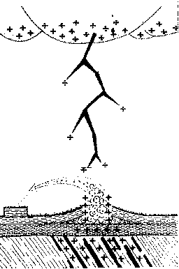
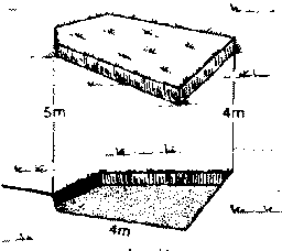
The divot from an Andøva moor Yes, the cookie-cutter phenomenon has left its mark again: more mysterious divots and holes in the ground. T. Jo nassen has sent us a study of the phenomenon published in Ottar, a publication of the Tromse Museum, in Norway. Even better, he has provided a translation, from which we quote a few paragraphs: "About 1 km SE of Skogvollvatnet (a lake), at Skogvollmyra (a moor), a slab of turf 5.2 m long and 1.8 m wide, has, in an apparently inexplicable manner, torn itself loose from its 'mother turf' and placed itself 4-5 m away. The slab of turf is completely undamaged and is placed with the right side up. The piece of turf has rotated 20-30 degrees compared to the original hole. The hole in the moor is absolutely even at the bottom, and the angle between the bottom and its walls is 90 degrees. The hole is 30-35 cm deep, and its edges are nicely cut. "From the hole there is a crack running westwards for about 6 m. Close to the hole this crack is somewhat widened, and one side of the crack twists itself 25-30 cm above the other. This twisting decreases as one gets further from the hole. The crack gradually subsides, and it is hard to tell exactly where it ends. "About 12 m NW of the hole there is an arched crack of about 15 m lying with its concave side towards the hole. It is plainest in the middle. Here the side closest to the hole has been twisted upwards about 15 cm. Here also the crack gradually disappears at both ends. There is an open hollow beneath the part which has been twisted upwards, about 30 cm below the surface. One theory has lightning creating a steam explosion from underground water. If this were the case, one would expect to find some fusion of the earth and more havoc wrought to the divot. "The slab of turf has an area of about 5 m2 and this should give a weight of between 1500-1700 kg."


Top image: The divot from an Andøva moor. Above image: One theory has lightning creating a steam explosion from underground water. If this were the case, one would expect to find some fusion of the earth and more havoc wrought to the divot
**********
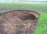
Strange Holes Discovered in Krasnoyarsk Region

**********
Strange Holes Discovered in Krasnoyarsk Region
